


Maryann Harris, Senior Executive Parks Superintendent, Dublin City Council presents a number of recent landscape projects which place horticulture at the forefront of flood mediation
Water features have been a major component of public parks design in Dublin for centuries. One of the earliest public promenades in Dublin was at the basin of the Grand Canal, where terraced walks provided a fashionable setting for the upper classes. Some of the water features in Dublin’s parks had other uses historically, such as the basin in Blessington Street Park, which was built around 1803 to provide a reservoir for the city water supply which until then was sourced from Lough Owel in Co. Westmeath. From the date of the completion of the Vartry Reservoir system in the 1860s, Blessington Street Basin’s water was then used exclusively to supply distilleries in Bow Street (Jamesons) and John’s Lane (Powers) and this continued until 1970 and 1976 respectively. Many older parks have formal ponds, such as St. Anne’s and Herbert Parks, and these would have been designed for contemplation and stocked with ornamental fish and exotic plants. Natural wetlands were not considered to be attractive or desirable.
Dublin City is situated on a Bay which would have originally been surrounded by wetlands and marshes supplied with fresh water from estuaries of the Liffey, Tolka, Santry and a number of smaller streams. As the City grew, and particularly in the 18th and 19th Centuries, these marshes were gradually filled in (mainly with the city’s refuse) and developed to expand the port of Dublin. The growth of Ringsend, Irishtown and Sandymount, in particular, was due to infill of natural wetlands. Ringsend Park and Irishtown Nature Park were both created over landfills from the 19th and 20th Centuries. Today, the entire Bay is developed with very few natural edges remaining. Most of the Bay is designated as a European Union Special Protection Area for migratory birds which rely upon the rich habitats for feeding after their winter journeys from Arctic Canada, Iceland, Greenland, Scandinavia and Russia. There are also two RAMSAR sites in Dublin Bay, which have given further recognition to these important wetlands.
Although natural wetlands were not valued in the past and there was a preference for formal water features in parks, views have changed over the past fifteen years. The idea of creating wetlands in parks in Dublin City is now driven by policies of the City Development Plan and also green infrastructure strategies of the Regional Planning Guidelines.
The turning point has arisen in part because of three factors:
1. Recognition of global biodiversity loss internationally and by the EU following the signing of the Convention on Biodiversity (CBD) at the Rio Summit in 1992
The first factor resulted in Ireland being a party in ratifying the Convention, which obliged us to produce a National Biodiversity Action Plan. County Biodiversity Action Plans followed subsequently and now each local authority and government body is obliged to dedicate resources to the protection of biodiversity. These plans mandate for provision of habitats which include wetlands as they are some of the habitats of highest biodiversity in Ireland. In urban areas such as Dublin City, the lack of available undeveloped land has put greater demands on public parks to perform ecosystem functions and provide ecological structures.
2. Increased frequency of flooding of property in Dublin City due to rapid high-density development in river catchments (a.k.a. Celtic Tiger) combined with global and local climate change effects
Although the records of Dublin Corporation show that the flooding of the city’s rivers had caused loss of life and property in the past, the frequency of severe storms has increased in recent years. This has caused the City Council to revise its engineering criteria for new build and to ensure flood prevention in accordance with the EU Floods Directive and the City Development Plan. Higher engineering standards bring higher costs, and so ‘soft engineering solutions’ are seen as a preferable option. Increasingly, the City Council is requiring reduced or even 0% discharge from newly built projects, particularly in areas where stormwater drainage is at capacity or where there is a history of localised flooding. As a result, existing and future public open space will be required to provide stormwater management controls in the form of ponds for detention or even permanent retention of volumes.
The problem is exacerbated for the city because it is downstream of all of its river catchments and is receiving stormwater runoff from developments in adjoining local authorities upstream. Cumulative impacts of developments during the Celtic Tiger which have permitted stormwater runoff at higher levels than previously greenfield sites result in increased flooding at river’s end. This is particularly heightened when shallow Dublin Bay is in a high tide situation – it is similar to a bathtub where the plug cannot be removed.
The drive toward such high-density development during the Celtic Tiger years was further promoted by successive governments as a solution for ‘sustainable development’. Sustainable development targets were agreed at the CBD at Rio. However, in Ireland, this concept was turned on its head somewhat by promoting increased pressure on existing green space, including the highly sensitive designated coastline of Dublin Bay. Under the Residential Density Guidelines (1999 and revised again in 2009), developers of greenfield sites (former agricultural lands) could provide less than the standard 10% quantity of public open space and parklands by paying to ‘upgrade’ (intensify) existing parks and open spaces or just by virtue of being near a railway station or the coast. This is stated in the 2009 Guidelines:
‘4.21 It will be necessary for planning authorities to take a more flexible approach to quantitative open space standards and put greater emphasis on the qualitative standards outlined above. Where residential developments are close to the facilities of city and town centres or in proximity to public parks or coastal and other natural amenities, a relaxation of standards could be considered. Alternatively, planning authorities may seek a financial contribution towards public open space or recreational facilities in the wider area in lieu of public open space within the development.’
(Residential Density Guidelines 2009)
These Guidelines are still active. Many of the developments currently under NAMA were granted permissions over ten years ago on the basis of weaker environmental legislation and practice and without complete assessment of the impacts of loading high-density development onto the existing green infrastructure. These impacts include the intensification of existing parks to cater for increased numbers of recreational users, resulting in the removal of some natural areas. Some of the projects I will discuss in this article arose out of the planning consents given under these Guidelines which obliged Dublin City Council to take stormwater from surrounding new developments in existing parks.
3. Greater Dublin Strategic Drainage Study(GDSDS) 2005
This document was a significant breakthrough in thinking on water quality management for Dublin and was the first such comprehensive report which began to recognise and document the full extent of stormwater impacts in the Dublin region. It highlighted: the problems of pollution of water quality of rivers from diffuse sources; the need to leave buffer areas (20-30 m was suggested) from development along rivers to protect biodiversity; the issues of combined sewer overflows sending raw sewage into rivers; the realities of climate change locally. It proposed Sustainable Urban Drainage Systems (SUDS) as a major solution for new developments to control and treat stormwater in the Dublin region. Although it was primarily an engineering initiative, it called for a greater requirement to involve other professions including horticulture, landscaping and ecology professionals. Had the GDSDS been fully funded and implemented, it would have been cost-effective and transformed development standards during the boom. Some of the recommendations of the GDSDS have been slowly brought into county development plans and SUDS practices are being expanded in the new Draft City Development Plan. Policies on buffer areas are in some county development plans (for example, Fingal) but have not been progressed in others.
Since then, wetlands have been constructed in many new and existing parks and open spaces in Dublin City for different purposes:
● Interception of domestic effluent – Tolka Valley Park
● Treatment of stormwater – Tolka Valley Park 2
● Avoidance of polluted run-off to flood zone and Special Protection Area (SPA) – Fr. Collins Park
● Retention and detention areas for reduction of flooding – Poppintree Park
● Promotion of biodiversity – all of the above
TOLKA VALLEY PARK
Much of the park north of the River Tolka at Finglas was a former local authority landfill which was pre-EU Directive (prior to 1977). Landfills of this era were not designed and therefore were not capped and did not have systems to treat effluent. Leachate from groundwater seepage from the landfill is a common problem. The soils are highly compacted and anaerobic and the slope gradients are extremely steep, therefore posing challenges for maintenance and cultivation. The river catchment spans three local authorities – Meath, Fingal and Dublin City – and had experienced a rapid growth in development, causing cumulative impacts downstream. The estuary of the River Tolka is an EU-designated Special Protection Area (SPA) for birds under the Birds Directive. Therefore, it is essential that any works upstream are carefully screened to consider downstream impacts. While some of the designated species are mainly remaining in the estuary, some do travel upstream and the river is a rich corridor for biodiversity. Furthermore, under the EU Habitats Directive, we have to manage the river corridor to maintain links between natural areas, or ‘connectivity’, for designated species of wildlife such as otter and bats.
The water quality status of the Tolka had been ‘Q2’ which means ‘fairly polluted’ for many years. Salmon and dipper, species which indicate clean water, had not been recorded for 100 years. Although wild trout have been stocked for years in the river by the local angling association, water quality was seriously impaired, and occasional fish kills from the effluent from industrial estates were common. Domestic misconnections in surrounding housing estates resulted in visible soap suds from drains into the river. The City Council had been doing household inspections, but it was a continuing problem. The old road network in the area had no drainage system and road run-off and agricultural drains flowed directly to the river.
It was decided to intercept and treat the issue within the park. The wetlands were created in two stages. The first stage, which took place in 1998-99, was to trial and monitor the effectiveness of two ponds to treat the domestic effluents. This was one of the first successful municipal constructed wetlands in Ireland.
As part of the Tolka Valley Greenway, levels were being altered further upstream to construct a park extension and a cycle route of 3.2 km through the entire park, old and new. As part of these works, three wetlands were constructed in the new section to provide a full treatment train for the road run-off and to tie into the old agricultural drains. The planting scheme included plants specific to each water quality stage and also across a range of depths. The wetlands became an attractive feature for walkers with a picnic area and native trees planted. During cycle route construction, additional gravel filtration trenches were constructed to intercept the landfill leachate and further improve water quality in the old section of the park.
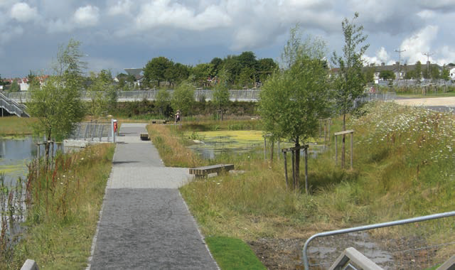
AVOIDANCE OF POLLUTED RUN-OFF TO FLOOD ZONE AND SPA – FR. COLLINS PARK
The Area Action Plan of 2000 for the area called by planners ‘The North Fringe’, which was mainly agricultural fields on the border of Dublin City and Fingal councils, included a ‘central park’ to which a series of pocket parks were linked by a cycle route (‘the green route’). The design for the central park was procured through an international design competition in 2003, which resulted in the selection of the winning entry by Abbelleyro+Romero Architects from Buenos Aires, Argentina. Father Collins Park was named after a local parish priest who was instrumental in securing the lands for public ownership for recreational use in the 1970s and it opened in 2009. The design concept was for a ‘sustainable park’. A key feature of this concept was to include wetlands which would hold and treat stormwater so that the park was self-contained and did not contribute run-off to the River Mayne. The river has a large floodplain and empties into Baldoyle Estuary, another EU designated SPA and also a National Nature Reserve. The Mayne has many existing water quality problems – many derived from receiving inputs from industrial lands around Dublin Airport – and is not meeting good water quality status under EU legislation.
There are seven wetland features within the park, including the lake along the central promenade or ‘spine’ of the park. These are fed by groundwater and a borehole was installed within the park. The wetlands serve to hold stormwater and


| FR. COLLINS PARK; PHOTOS BY: MARYANN HARRIS |
runoff from the playing pitches and this can be beneficial in reducing runoff from fertilisers to the already compromised Mayne. This area of north Dublin has a high groundwater table. The wetlands and lake were lined with a recycled rubber liner. The material was imported from Spain as the specification for recycled material was unavailable in Ireland, thus time was an issue awaiting delivery. The installation of the liner was slow, due to an unseasonably poor summer in 2008 followed by cold weather in autumn. The material can be unwieldy to handle and cannot be installed in windy or cold conditions. Furthermore, in the initial opening stages of the park, we had rising groundwater under the liner which could cause visible expansion areas. Based on our experience from this, I have since found that, for most sites in north Dublin, we can obtain a natural liner with some modification of selected local soils in accordance with the Departmental guidelines (DoELG 2010). I would recommend seeking advice and testing by a structural engineer qualified to assess soils to be used for this purpose, especially if the wetland is trapping pollutants and is near a natural watercourse or could release these to groundwater. If a wetland base fails and groundwater seepage occurs, pollutants could be released and cause damage to water quality. If in doubt, then use of a liner is essential to protect the environment and avoid any liabilities.
One advantage of the liner was its dark colour which gave the impression of greater depth than is actually the case. This was selected through the health and safety risk assessment. Other measures to ensure public safety of the wetlands, which have no barriers around them, were: contouring to ensure a shallow shelf for a minimum of two meters in distance from any edges; planting of all edges to create a visual and physical barrier to access; tactile paving strips along path edges on the promenade for the visually impaired; signage to inform the public; lighting of the edges of the main water feature at night (powered by the park’s wind turbines) and keeping depths to the minimum.
The development of Fr. Collins Park was funded by levies paid by developers throughout the North Fringe area, in lieu of the provision of significant public open spaces in line with the aforementioned national guidelines for residential development. However, since those planning permissions were granted (mainly in 1999-2001), the City Council has sought to increase provision of SUDS measures to meet the revised criteria. The difficulty has been that it is impossible to apply criteria to existing permissions and, even in the case of those that come up for renewal, to lands that have virtually no green spaces to accommodate them.
RETENTION AND DETENTION AREAS FOR REDUCTION OF FLOODING – POPPINTREE PARK
Poppintree Park is situated within the zone for the biggest urban regeneration scheme at the time in Europe – Ballymun. The main objective was to provide low-density housing for people living in the well-known tower blocks. This naturally required significant additional lands for new development. Part of these lands was taken from the existing public park at Poppintree. The scale of the development created significant issues for increased stormwater volumes. Most of the groundwater and surface drainage systems in the locality feed into underground and old culverted rivers which descend into the River Tolka. Due to the ongoing concerns about flooding of the Tolka, it was decided that some of the stormwater be stored in the remaining portion of Poppintree Park. The design included for several types of wetlands: a permanent retention pond to be designed as a formal pool with steps down to it but which could fluctuate in depth by a metre; two detention ponds which were informal grassed areas but could store stormwater; a large basin with a mown lawn which could be used seasonally for kick about but which could detain water on a temporary basis and included some permanent wetland areas.
The new park opened in 2010. It won a Local Authority Management Award in 2011 and received a Green Flag in 2015. The wetlands have had mixed success. The formal pond is a main feature of the park, but the fluctuating levels meant the island within it, originally intended to provide a nesting area for wildlife, was occasionally inundated. This has been modified, but the island is still somewhat small to provide meaningful habitat and protection from disturbance for nesting birds. The large basin became wet for much of the year, due to high groundwater levels which seem to have increased from the expected levels which informed the design. This may be a reflection of increased localised flooding. However, the expectation that it would function for a kick about was largely unmet, due to the wet conditions. Biodiversity surveys show that the wetlands here are certainly performing well and that species diversity is increasing in the park.
CHALLENGES IN IMPLEMENTATION
Whenever a new approach is explored in the context of public green space, it is, of course, open to debate and public opinion. It is fair to say that some of our wetlands projects have been very well-received, even winning national awards. The media focus has been generally positive as well. However, there are instances where members of the public and their representatives have questioned the provision of wetlands. The main concerns expressed are: safety hazards, especially for children and the visually impaired; taking up space otherwise could be used for recreation (kick about); too untidy looking; mucky and muddy and children getting their clothing dirty playing around them.
While constructing wetlands in parks can provide for wildlife and increased biodiversity, there is a strong demand by some members of the public to put fish in the ponds. These may be requests to form local angling groups for coarse fishing, which can be genuine efforts to build a sense of community and a positive activity for youth. It is difficult to refuse such requests. However, the impact of fish as predators will reduce biodiversity. Of course, the stocking of some of our ponds with Koi by members of the public is of little benefit to angling or biodiversity. Wetlands can also become host to unwanted pets, and we have had to deal with turtles, which are destructive of nesting birds and some are designated invasive species, being released. Some people still view wetlands as waste areas, and we have had ongoing issues with dumping into ponds of refuse. This highlights the need for serious education and also enforcement. The removal of dumped material by boat carries increased health and safety risks to staff maintaining parks and is also time-consuming. Dumping of alcoholic beverage containers, including part-full beer cans, adds further problems for wildlife as it reduces oxygen levels and damages water quality and plant growth.
CONCLUSIONS
● Scrap the Residential Density Guidelines 2009.
● Go back to the GSDS.
● Siting of wetlands needs to consider on a catchment basis how to achieve strategic points to intercept run-off or to store water and slow flows.
● When choosing solutions to flooding, it is important to consider the total benefits beyond just flood alleviation but also for biodiversity.
● There is a need to review and learn from schemes already constructed to inform best practice in Ireland.
References:
– Dublin Drainage Consultancy (2005). Greater Dublin Strategic Drainage Study. Dublin: Dublin City Council.
– Department of Environment Heritage and Local Government (DOEHLG) (2009) Guidelines for Planning Authorities on Sustainable Residential Development in Urban Areas (Cities, Towns & Villages). Dublin: DOEHLG.
– Department of Environment Heritage and Local Government (DOEHLG) (2010). Guidance Document for Farmyard Soiled Water and Domestic Wastewater Applications. Dublin: DOEHLG. ✽


